GeoAI Intelligence Platform

Analyze location potential, monitor network performance and manage expansion — based on proprietary GeoAI technology, mobile data and machine learning.
MacBook mockup
GeoAI Intelligence Platform

Grow your network with data and  
insights for each location

Advanced location intelligence and AI technology trusted by more than 60 networks in Poland. Dozens of data sources, proprietary ML models and AI support in the interpretation of results.

Asses the potential of every location

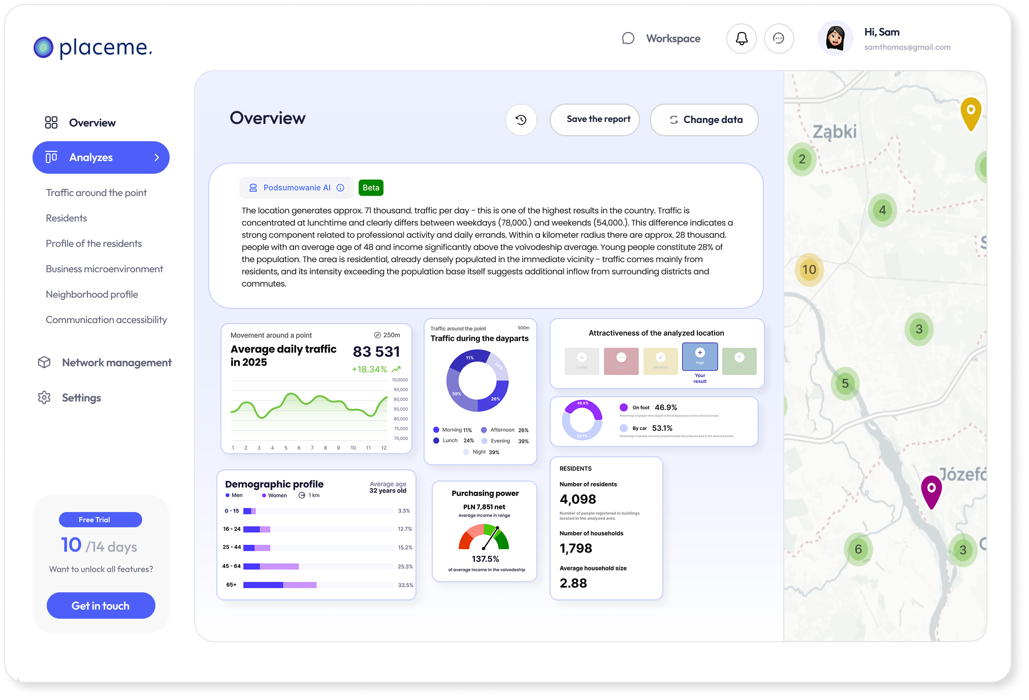
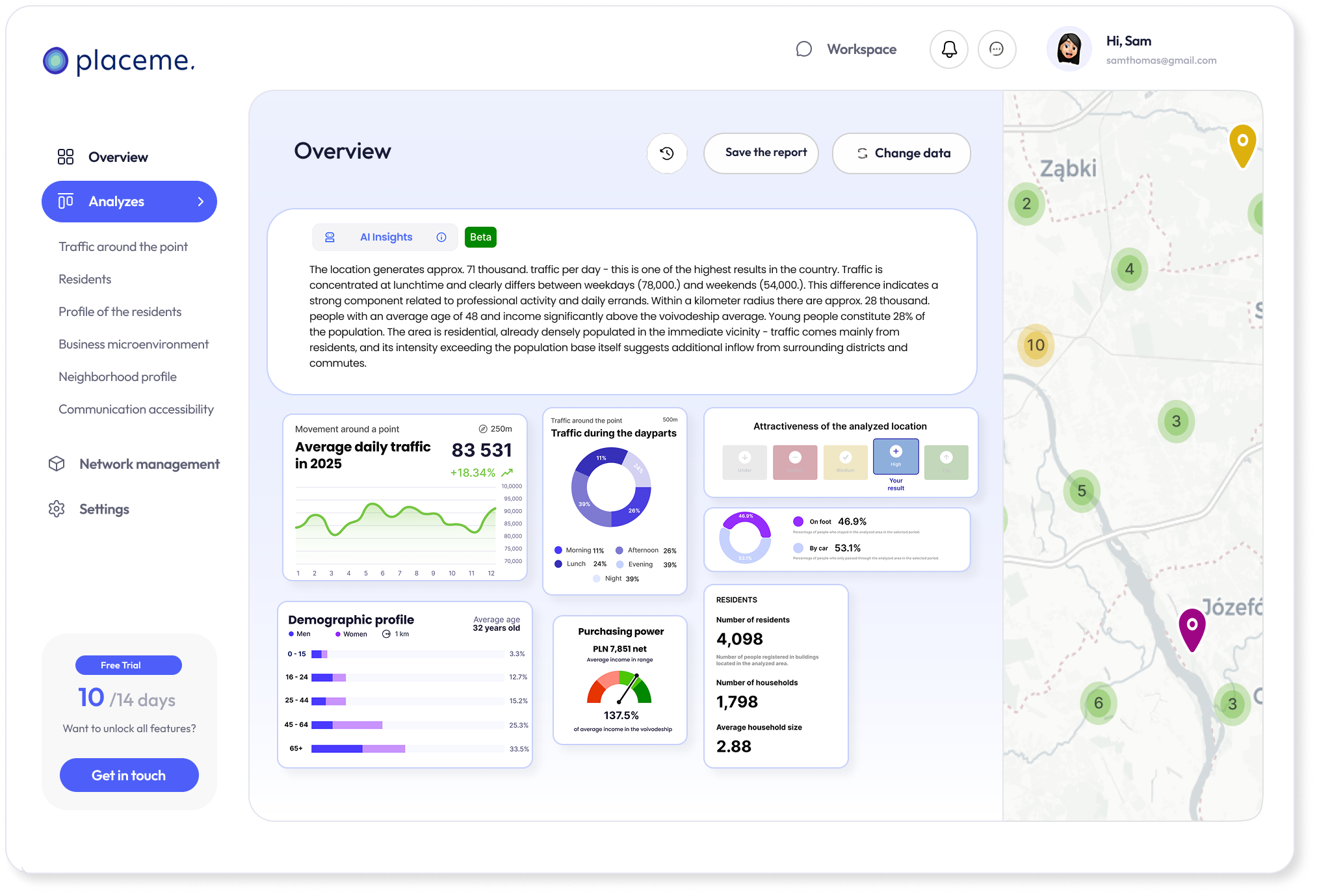
Check the actual traffic, demographic profile, purchasing power and competitive environment of any address in a few clicks. Automatic potential indicators, benchmark to the existing network and AI summary allow you to quickly assess the location in an understandable way.
Location analysis ➞

Analyze the current network

Monitor traffic dynamics around network points, measure impact ranges and market shares against competitors. Analyze co-visitation, identify white spots with the highest potential for new locations, and track visitor trends over time.
Network analysis ➞

Area management

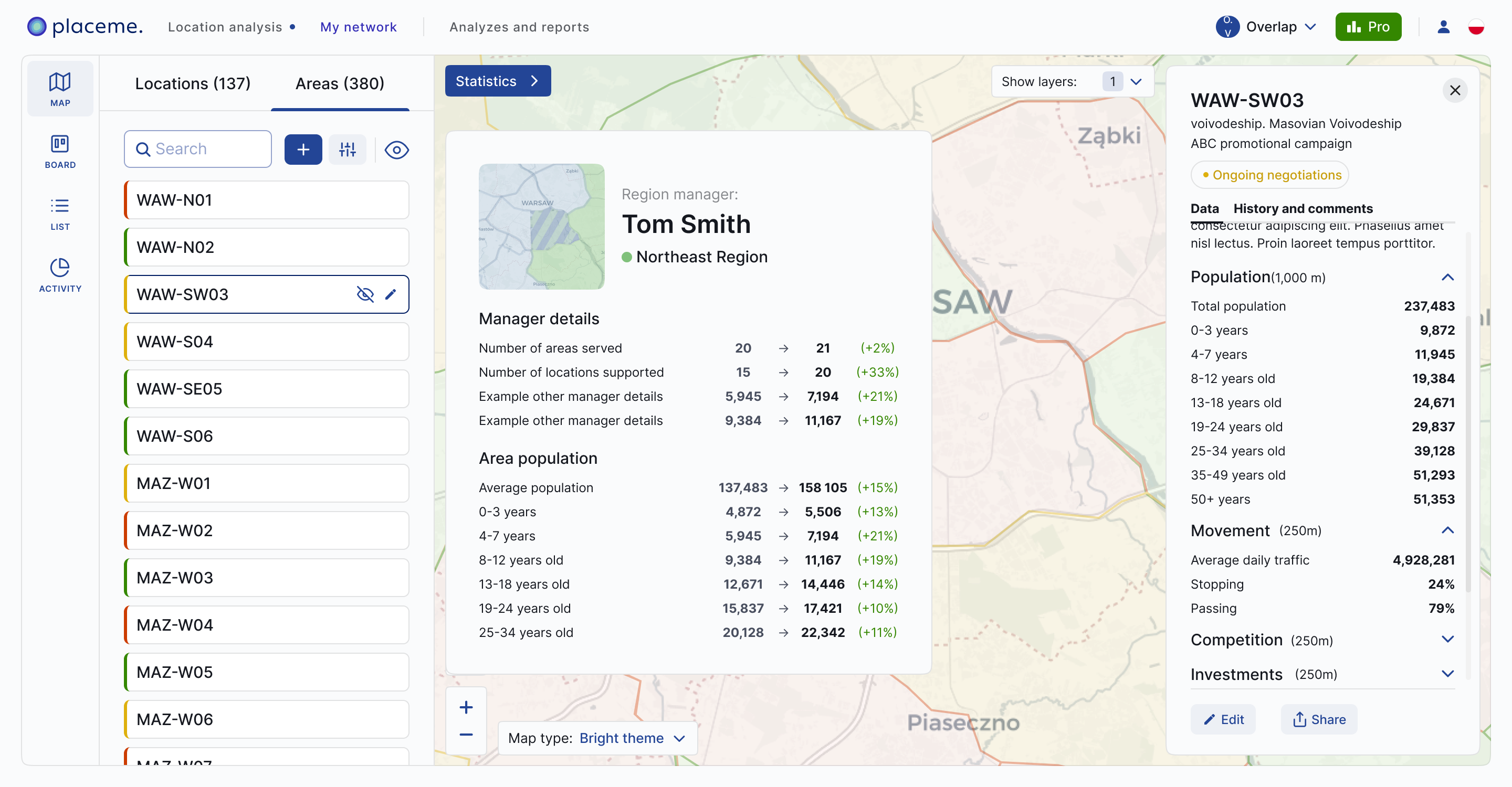
Manage your areas and expansion team from a single tool. Assign regions, monitor fieldforce performance and control pipeline openings on Kanban board. The map view gives you a complete overview of the location and status of each point on the network.
Area management ➞
GeoAI Intelligence Platform

Everything you need to make location decisions in one app

Placeme is a platform that supports growth of the network in a comprehensive way. From the identification of areas with potential, to the evaluation of specific locations, to the management of the expansion team and the monitoring of statistics of the entire network.

Advanced traffic indicators

Traffic, dynamics, seasonality and advanced mobility metrics – based on signals from millions of mobile devices and updated daily.

Proprietary ML models

Machine learning identifies key dependencies in data and translates them into ready-made analyses. Our extrapolation models ensure the accuracy of traffic forecasts above 90%.

AI Insights Support

The AI interprets the results, highlights the most important conclusions, and helps you quickly assess a location without looking at dozens of metrics.

Maps and visualizations

Interactive hexagonal maps, traffic visualizations, demographic heatmaps and network views. Data presented in a form that allows you to draw conclusions right away.

Teamwork

One workspace, shared reports with a link and a single location assessment standard for the entire team. Everyone works on the same data, in the same process and with the same indicators.

Potential indicators

The attractiveness index evaluates the location in the context of your business, and the benchmark compares it with existing network points. A quick answer to the question “is this a good location?”.
Comprehensive location analysis

Assess the potential of each location in a few clicks

Analyze any point - from the center of a big city to a small village in a rural municipality. Enter the address or coordinates, define the scope and build a report tailored to the needs of your business. Define the range of the analysis with radius, pedestrian access time, car or bicycle travel, or draw it manually on the map.

Analiza lokalizacji w aplikacji Placeme - ocena potencjału każdego adresu
360° image of the sales network

Analyze your network and plan growth basing on the full context of the data

Mockup
How optimal is my network?

Network analysis

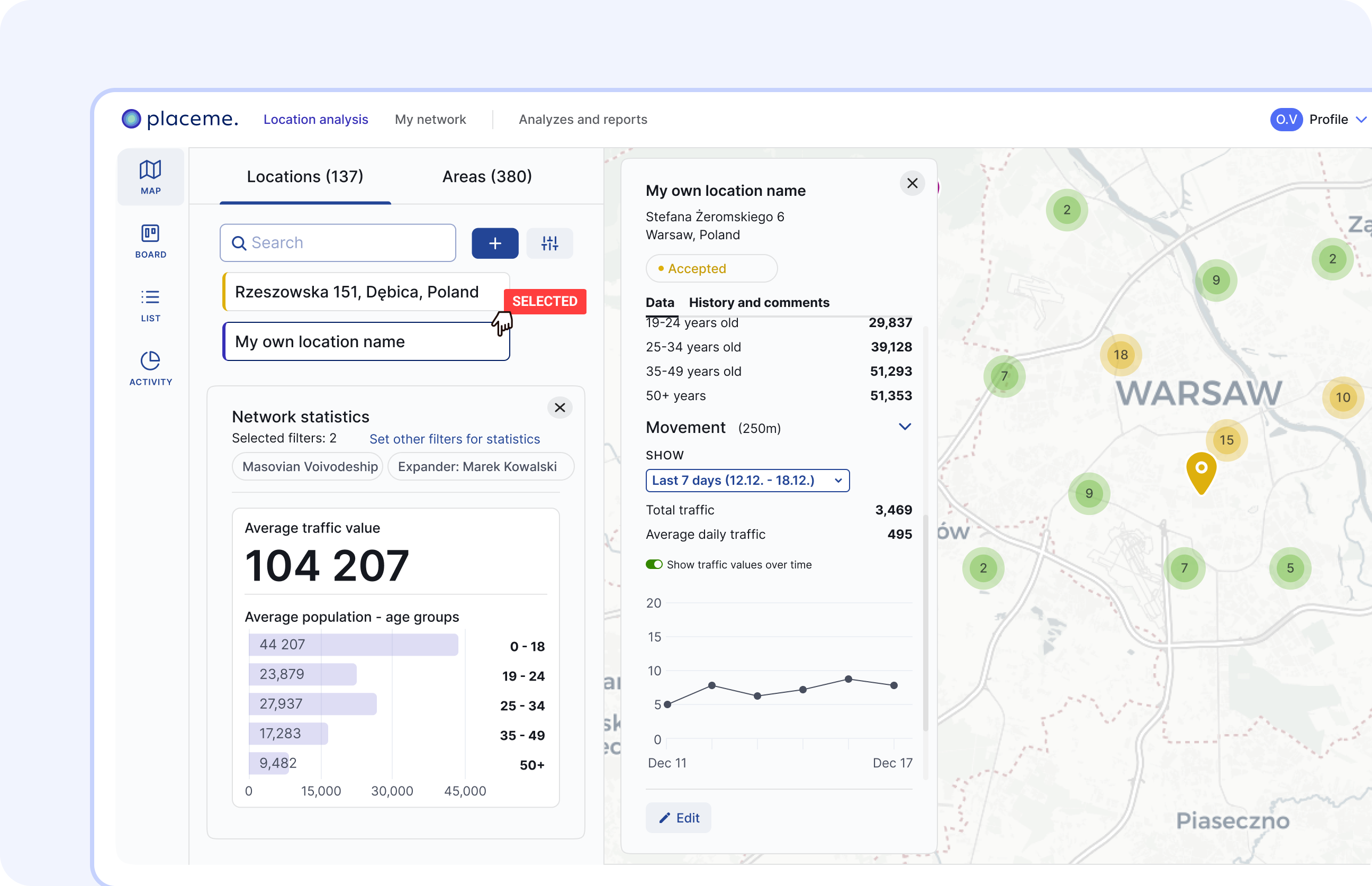
Immerse yourself in the data of each point — traffic, demographics, competition, the nature of the environment. Identify locations that perform below potential. Segment your network by spatial characteristics, not just sales performance.
Mockup
My network vs. the competition

Market position

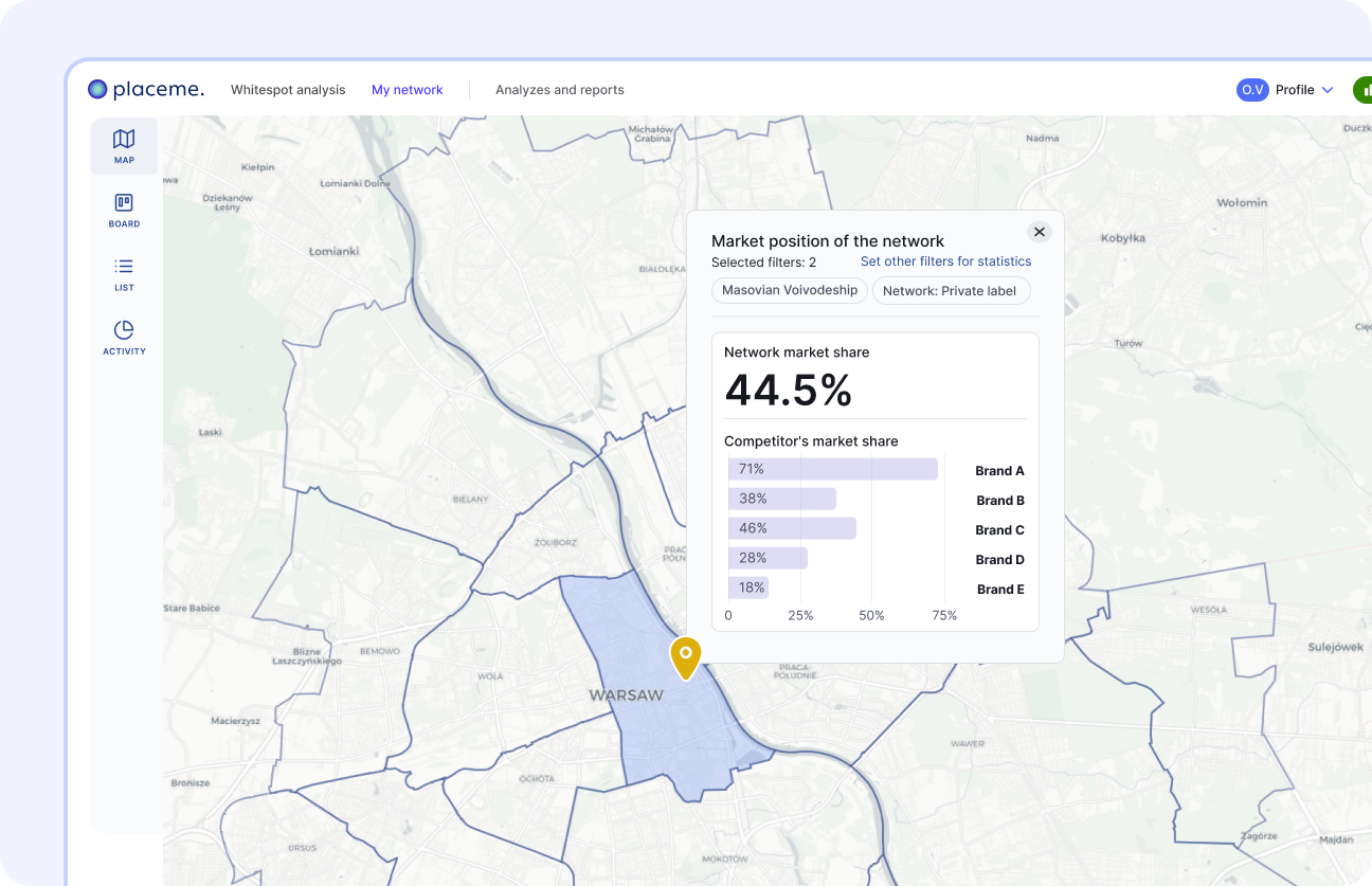
Measure the market share at the level of the whole of Poland, provinces and micro-markets. See what part of the population and traffic you are reaching against the competition. Identify regions where your position is weakening before it translates into results.
Mockup
How can I further develop the network?

Directions of expansion

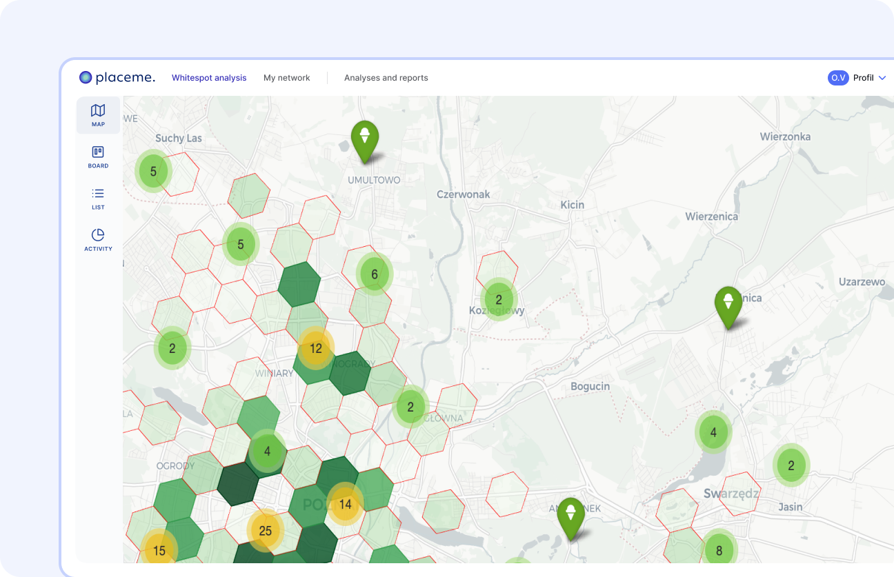
Find areas with the highest potential for new locations and assess market saturation region by region. Automatic scoring evaluates each address in the context of your network's success factors.
Dashboard Moja siec w aplikacji Placeme - zarzadzanie siecia
Collaboration and team management

Manage network areas and team in one place

Explore the entire network on a map, monitor point statistics and manage the process of evaluating new locations. The Kanban board organizes the pipeline from the potential point stage to the open, and labels allow you to segment the network by regions, formats or priorities. The whole team works on the same data and criteria.

Do you have any questions?

Let's talk
Let's talk

Schedule an interview with us, we will be happy to answer any questions and tell you exactly how to use our tools in your industry and business.

Join the...

Icon - Elements Webflow Library - BRIX Templates
GeoAI Intelligence Platform

FAQs

Everything you need to know about Placeme. Didn't find the answer? Contact us.
What is Placeme?
Placeme is a GeoAI Intelligence Platform that combines location potential analysis, network monitoring and expansion management in one tool. The platform is based on proprietary location data processing technology, machine learning models and AI layer.
How does Placeme differ from other location analysis tools?
Placeme combines location analysis, network monitoring and expansion management in one platform — with proprietary ML models, geospatial data from dozens of sources, and an AI layer. Most tools on the market cover only one of these areas.
Who is Placeme for?
For retail, service and franchise networks that develop a network of physical locations. Placeme is used by expansion teams, operations directors and analysis departments in more than 60 companies in Poland.
What locations can I analyze?
Any address in Poland — just enter the address, GPS coordinates or put a pin on the map. You define the scope of the analysis with radius, travel time, or manual stroke. Traffic data is also available for EU and UK countries.

How does AI work in Placeme?
AI Insights automatically generates a summary of each analysis in understandable language — interpreting the results, highlighting key findings, and helping you assess the location without looking at the data yourself.
How soon can I start using Placeme?
Once you create your account, you have instant access to analytics. On request, we arrange a 30-minute implementation training to use the full potential of the tool from day one.